Mastering unmanned aerial vehicle operation requires more than just reading a manual. The Agriculture Drone Simulator provides a powerful solution for modern pilots. This advanced platform offers a safe space to build essential skills.
You can practice without the fear of damaging expensive equipment. The system bridges the gap between theory and real-world application perfectly.
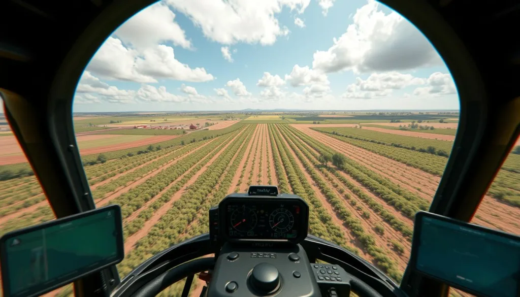
The experience is incredibly immersive. The software features photo-realistic graphics with stunning details. You will see glowing city lights, flying birds, and shimmering water reflections.
There are six massive digital worlds to explore. Each covers up to 20 square kilometers. Landscapes range from bustling cities and quiet countryside to active construction sites and vast fields.
This drone simulator supports three different UAV types. You can train with multirotor, fixed-wing, and VTOL aircraft. Over 20 digital twins of popular professional models are available.
This comprehensive approach to training covers everything from basic maneuvers to complex mission planning. It is the ideal tool for building confidence before your first real flight.
Key Takeaways
- This simulator provides a risk-free environment to learn and practice drone piloting.
- The graphics are highly realistic, featuring detailed digital worlds for immersive training.
- Users can explore six large, diverse landscapes, each spanning up to 20 square kilometers.
- The platform supports training on multiple UAV types, including multirotor and fixed-wing models.
- It is designed to help both beginners and experienced operators build competence and confidence.
- Mistakes become valuable learning experiences without the cost of real-world accidents.
Overview of the Agriculture Drone Simulator
Transitioning from theoretical knowledge to practical field skills is a critical step for any UAV professional. This platform serves as a comprehensive training solution, blending realistic flight physics with authentic scenarios.
It combines professional-grade features into one integrated system. This allows for a seamless learning experience.
Product Introduction and Unique Selling Points
The system’s strength lies in its extensive library of digital environments. Users can practice in conditions ranging from calm daylight to windy nights or dense fog.
Authentic weather simulation is a core component. This prepares operators for any situation they might face.
Integration with industry-standard flight control software, like QGroundControl, is a key advantage. It enables the management and execution of autonomous missions with remarkable accuracy.
“The ability to rehearse complex tasks in a risk-free digital space is transformative for skill development.”
Key Benefits for UAV Operators
Pilots gain significant advantages. They can develop skills without the fear of damaging expensive equipment.
Training costs are drastically reduced. Unlimited practice opportunities are available in diverse weather conditions.
This tool also helps users meet regulatory requirements. It provides a way to demonstrate proficiency safely and effectively.
The confidence gained here translates directly to improved performance with actual unmanned aerial vehicles in the field.
Immersive Flight Simulation Environment and Graphics
Exceptional graphics quality separates professional training tools from basic practice applications. The visual environment creates an authentic learning experience that builds real operational confidence.

Photo-realistic Digital Worlds
Six massive digital landscapes provide diverse training scenarios. Each covers up to 20 square kilometers with stunning detail.
You’ll find bustling cities, quiet countryside, and active work sites. Realistic lighting effects include glowing urban areas and shimmering water reflections.
Flying birds and moving traffic signals enhance the immersion. These elements create training scenarios that feel genuinely authentic.
Dynamic Weather and Time Conditions
The advanced weather system prepares operators for real challenges. Practice ranges from calm daylight to stormy nights with heavy rain.
Dense fog and windy conditions test your skills thoroughly. Different lighting situations mirror actual field operations perfectly.
This dynamic simulation helps understand how conditions affect equipment performance. Battery life and sensor accuracy change with environmental factors.
Training in varied scenarios ensures readiness for any mission. The combination of visual quality and changing conditions creates unmatched preparation value.
Diverse UAV Types and Drone Models
Professional UAV operators benefit from understanding how different aerial vehicle designs serve specific mission requirements. The platform includes three main uav types with distinct flight characteristics and applications.
Multirotor, Fixed-wing, and VTOL Examples
Multirotor models excel at precision tasks requiring stable hovering and close-range observation. Their vertical takeoff and landing capabilities make them perfect for detailed field inspections.
Fixed-wing aircraft cover large areas efficiently. They operate like traditional airplanes, using forward motion to generate lift. This design allows extended flight times for mapping and surveying.
VTOL (Vertical Take-Off and Landing) systems combine the best features of both types. They launch vertically like multirotors but transition to efficient fixed-wing flight for longer missions.
The system features over 20 digital replicas from leading manufacturers. Each model replicates authentic flight dynamics and performance characteristics. This variety helps operators select the right equipment for their specific needs.
Training with multiple uav types builds versatile skills that transfer to real-world operations. Operators gain confidence working with different configurations and understand which designs work best for various tasks.
Integrated Flight Control and QGroundControl Features
Mastering autonomous mission execution requires hands-on experience with the same software tools used in actual field operations. The platform integrates QGroundControl, a professional open-source ground control station. This gives users authentic practice with industry-standard mission planning.
Autonomous Mission Management
Operators can plan complex routes using waypoint navigation systems. The software supports automated takeoff and landing sequences for safe practice. Altitude control and pre-programmed flight patterns prepare users for agricultural surveys.
Switching between manual control and autopilot modes builds versatile skills. This flexibility allows pilots to develop both hands-on flying techniques and automated mission execution. The system mirrors real-world workflows from planning to data collection.

Seamless Open-Source Integration
The simulator supports integration with two leading autopilot platforms: PX4 and ArduPilot. These are the most widely used open-source flight control systems in commercial operations. Users gain proficiency with the exact software they’ll encounter professionally.
Learning QGroundControl features in this risk-free environment provides significant advantages. Operators develop confidence before controlling actual UAV equipment. This preparation ensures smoother transitions to field operations.
Proficiency with these industry-standard platforms is essential for professional aerial vehicle operators. The integrated approach builds comprehensive skills that directly translate to successful mission outcomes.
Engaging Training Missions and Real-World Scenarios
The true value of any training platform lies in its ability to replicate authentic operational challenges. This system features an extensive library of practice exercises designed around common professional situations.
Each scenario provides specific objectives and success criteria. This helps users track progress and identify areas needing improvement.
Aerial Photography and Inspection Missions
Operators develop essential documentation skills through various photography assignments. These include sunflower field surveys, construction site mapping, and village documentation projects.
Proper camera positioning and flight pattern execution become second nature. Inspection tasks over polluted coastlines and countryside environments teach careful observation techniques.

Stable flight control and thorough documentation methods are emphasized throughout. These missions prepare pilots for routine monitoring work.
Emergency and Cargo Delivery Challenges
Crisis response skills develop through urgent delivery scenarios. One mission involves transporting supplies through a burning forest area.
Another task requires delivering first aid kits to remote tourist locations. These exercises build quick decision-making abilities under pressure.
Practicing these diverse mission types creates muscle memory and situational awareness. The skills gained transfer directly to field operations with unmanned aerial vehicles.
Advanced Simulation Technologies and Autonomous Features
Modern aerial vehicle operations increasingly rely on sophisticated autonomous systems that require specialized training. This platform incorporates cutting-edge technologies that prepare operators for next-generation equipment.
The system includes three powerful autonomous features that represent the future of aerial operations. Each technology provides realistic practice with emerging capabilities.
Collision Avoidance Algorithms
Intelligent obstacle detection systems automatically identify hazards along flight paths. The algorithm calculates the most efficient trajectory to avoid collisions.
This technology maintains mission efficiency while ensuring safety. Operators learn to trust automated navigation systems in complex environments.
Computer Vision and Swarm Coordination
The computer vision system reads ArUco markers to analyze routes accurately. It centers the vehicle and commands precise navigation to designated waypoints.
Swarm coordination demonstrates how multiple units operate simultaneously. The team of aerial vehicles maintains formation while changing positions safely.
| Autonomous Feature | Primary Function | Training Benefit |
|---|---|---|
| Collision Avoidance | Detects and avoids obstacles | Builds trust in automated safety systems |
| Computer Vision | Analyzes routes using marker recognition | Develops precision navigation skills |
| Swarm Coordination | Manages multiple unit formations | Prepares for fleet operations |
These advanced capabilities represent where aerial technology is heading. The development team has implemented sophisticated algorithms for realistic training.
Hands-on experience with these systems prepares operators for evolving professional requirements. This simulation platform ensures readiness for next-generation drone technologies.
Customizable Weather and Environmental Conditions
Environmental variability presents the greatest challenge for operators working with aerial technology in real-world settings. The platform’s comprehensive weather system allows users to create specific conditions for targeted skill development.

Operators can adjust parameters in real-time, transitioning from calm daylight to challenging scenarios. This includes windy nights, heavy rain, or dense fog that tests adaptation skills.
Real-Time Environmental Adjustments
Training in adverse weather prepares pilots for critical safety decisions. Different atmospheric conditions significantly affect equipment performance.
Reduced visibility in fog tests navigation skills. Strong winds increase battery consumption during flight operations. Rain creates sensor limitations that operators must overcome.
The system also includes time-of-day variations for comprehensive preparation. Users practice from bright midday to twilight and nighttime missions.
| Weather Condition | Primary Challenge | Training Focus |
|---|---|---|
| Heavy Rain | Sensor accuracy limitations | Manual navigation skills |
| Dense Fog | Reduced visibility | Instrument reading proficiency |
| Strong Winds | Increased power consumption | Energy management strategies |
| Night Operations | Limited visual reference points | Lighting system mastery |
Customizable environment settings enable progressive skill development. Beginners start with ideal conditions before advancing to complex scenarios.
This simulator provides risk-free practice for all atmospheric situations. Understanding weather impacts is essential for safe and effective field work.
Controller Options and Flight Perspectives
Choosing the right control method can dramatically impact training effectiveness. The platform offers flexible operation options to match different skill levels and mission requirements.

Users can operate vehicles either manually or through automated systems. Both approaches help improve flight precision and overall control.
Manual and Autopilot Modes
Manual operation provides hands-on practice with throttle, pitch, roll, and yaw management. This builds fundamental flying skills through direct vehicle control.
Autopilot mode focuses on mission planning and waypoint navigation. It helps users understand how automated systems execute programmed flight paths.
Recommended physical controllers include Radiomaster, TBS Tango, Jumper, and FrSky Taranis models. These devices provide authentic tactile feedback for realistic training.
| Control Method | Primary Focus | Best For |
|---|---|---|
| Manual Mode | Direct vehicle operation | Building basic piloting skills |
| Autopilot Mode | Mission planning | Automated operation practice |
FPV vs. Third-Person Views
First-person view (FPV) places operators directly in the pilot’s seat. This immersive perspective is ideal for precision tasks and close-quarters maneuvering.
Third-person view offers broader situational awareness. It helps learners understand spatial relationships and overall flight patterns more effectively.
Switching between perspectives during training develops comprehensive spatial awareness. This adaptability prepares users for diverse operational requirements with any drone configuration.
“Mastering both control methods creates operators who can handle any situation confidently.”
Proficiency with different controllers and viewing angles ensures versatile skill development. This comprehensive approach supports effective training across various applications.
Technical Requirements and Hardware Specifications
The technical foundation of your computer system determines how effectively you can utilize professional training tools. Meeting the proper requirements ensures smooth operation and optimal visual quality.

Minimum vs. Recommended System Requirements
Basic functionality requires an Intel Core i5-12500 or AMD Ryzen 5 5600x processor with 16 GB RAM. The minimum GPU specification is an Nvidia 3060 ti with 8GB VRAM.
For optimal performance, choose an Intel Core i5-13500 or AMD Ryzen 7 5800x core processor. Recommended specifications include 32 GB RAM and an Nvidia 4070 GPU with 8GB VRAM.
Supported Operating Systems and Components
The software runs on multiple platforms including Windows 10, Windows 11, and various Linux distributions. Supported systems include Astra Linux 1.7 SE, Astra Linux 1.8, RedOS 8.0, ROSA Linux, and Ubuntu 22.04.
Meeting these technical requirements ensures users experience all features without performance limitations. Proper hardware selection guarantees smooth operation during intensive training sessions.
Flexible Licensing Options for All Users
The platform offers multiple entry points to accommodate various learning objectives and budgets. Three distinct licensing tiers provide scalable options for individual learners and organizations.

Free Trial and Full Version Benefits
A comprehensive free trial allows new users to test the system’s capabilities. This no-risk evaluation helps operators understand the platform’s value before purchasing.
The trial version includes full access to core features without activation requirements. This approach lets potential customers experience the training environment firsthand.
Comparing Base, Developer, and Professional Editions
The Base license focuses on fundamental flight maneuvers in manual and autonomous modes. It’s ideal for operators starting their aerial vehicle journey.
The Developer version specializes in programming practice without physical equipment. It supports autonomous flight algorithm development.
The Professional edition provides the total feature set available. This comprehensive package suits training organizations and commercial operations.
All versions share the core simulation environment. Pricing is available on request for customized organizational needs.
Activation Process for Full Version Software
Accessing advanced features requires a simple activation procedure that respects the user’s time. The platform offers two straightforward paths to begin your training journey.

Step-by-Step Activation Instructions
The free trial option provides immediate access. Simply complete the download form when selecting the trial option. Installation begins right after download completion.
No activation code is needed for the trial version. This allows new users to explore core features without commitment.
For the full software package, purchase your preferred plan on the website. The download link appears instantly on your order confirmation page.
You’ll receive an email with essential information. This includes both the download link and your unique activation code.
After installing the software, enter the activation code when prompted. This unlocks all premium features for your license duration.
Keep your activation details secure for future reference. The entire process is designed for quick setup and immediate training access.
Digital Solutions for Crop Management and Inspection
Digital mapping technologies have revolutionized how farmers monitor and manage their crops throughout the growing season. The platform teaches operators to capture geotagged photos during missions and process them using professional photogrammetry software.

This workflow creates precise digital terrain models and orthophotos. The system mirrors real-world agricultural mapping processes perfectly.
Integration with Photogrammetry Software
Users learn to import captured imagery into tools like Metashape for advanced processing. This generates detailed 3D reconstructions and accurate field maps.
The training covers the complete workflow from image capture to final deliverable creation. Operators gain practical experience with industry-standard software.
Commercial Crop Optimization and Yield Improvement
The platform provides intelligent management solutions for various commercial crops. These include cotton fields, citrus orchards, apple plantations, and tea farms.
Operators learn to identify crop stress, disease patterns, and irrigation issues through aerial analysis. This inspection service delivery helps farmers make data-driven decisions.
| Crop Type | Primary Inspection Focus | Economic Benefit |
|---|---|---|
| Cotton Fields | Pest detection and growth monitoring | Reduced pesticide use |
| Citrus Orchards | Fruit yield estimation and health assessment | Optimized harvest timing |
| Apple Plantations | Disease identification and canopy management | Improved fruit quality |
| Tea Farms | Leaf quality analysis and harvest planning | Increased premium product yield |
Mastering these digital mapping techniques prepares operators to deliver professional services that directly impact farm profitability. The training offers convenient, cost-effective alternatives to traditional inspection methods.
Industry Applications and Future Innovations
The applications for unmanned aerial vehicle technology continue to expand far beyond their original agricultural roots. This growth is mirrored in the evolution of advanced training platforms, which now prepare operators for a wide spectrum of professional challenges.
Advanced UAV Applications in Diverse Industries
Modern uav systems are vital tools in forestry management, environmental monitoring, and emergency services. These industries rely on precise data collection and rapid response capabilities.
The company has solidified its global presence through strategic partnerships. Key collaborations with Indian firms RapiFuzz and PDRL, alongside established operations in China, demonstrate the universal demand for quality training.
This international expansion ensures the drone simulator meets diverse operational standards. It prepares pilots for real-world missions across different continents and regulatory environments.
Emerging Trends and Technological Advancements
The development team continuously integrates cutting-edge trends into the simulation. Artificial intelligence, improved autonomous systems, and enhanced sensors are now core training components.
Future innovations focus on immersive experiences. Virtual reality integration and multi-user collaborative missions are on the horizon. Advanced analytics will provide deeper performance tracking for every operator.
This commitment to innovation ensures the platform remains at the forefront of uav training. The company maintains rigorous accreditation, guaranteeing its programs meet the highest professional standards.
Training with this forward-looking system prepares operators for the next generation of autonomous drones. It builds essential skills for applications across numerous industries, making it an invaluable investment for any serious company.
Conclusion
The journey toward mastering aerial vehicle operations finds its most effective starting point in digital practice spaces. This comprehensive training platform delivers realistic preparation for all skill levels.
From basic takeoff and landing to complex autonomous mission execution, operators build essential skills without equipment risks. The breadth of available models, weather conditions, and flight scenarios creates unmatched preparation value.
Experience the platform firsthand through our free trial. Discover how this approach accelerates learning and builds confidence for real-world operations. Quality virtual preparation develops the skilled operators needed for tomorrow’s precision applications.
FAQ
What are the main benefits of using a flight simulator for UAV training?
The primary benefits include significant cost savings by avoiding damage to expensive physical equipment, the ability to practice in a completely safe environment, and the opportunity to master complex flight skills and mission procedures without real-world risks. It allows operators to build confidence and experience efficiently.
What types of unmanned aerial vehicles can I simulate with this software?
The platform supports a wide range of UAV types, including popular multirotor models like quadcopters and hexacopters, efficient fixed-wing aircraft for long-range missions, and versatile VTOL (Vertical Take-Off and Landing) drones that combine the benefits of both.
Does the simulator include realistic weather and environmental conditions?
Yes, it features a highly dynamic environment. You can simulate various weather scenarios like wind, rain, and fog, as well as different times of day. These real-time environmental adjustments are crucial for preparing for actual field operations under challenging conditions.
Can I practice specific commercial missions, such as agricultural inspection?
Absolutely. The software includes dedicated training missions for real-world applications. These cover aerial photography, detailed infrastructure inspection, precision agriculture tasks like crop monitoring, and even specialized scenarios like emergency response and cargo delivery.
What are the computer system requirements to run the simulation smoothly?
For a good experience, a modern multi-core processor (like an Intel Core i5 or equivalent), a dedicated graphics card with at least 4GB of VRAM, and 8GB of RAM are recommended. Specific minimum and recommended requirements are available to ensure compatibility with your hardware.
Are there different licensing options available for individuals and teams?
Yes, there are flexible licensing plans to suit various needs. Options typically include a free trial, a base version for hobbyists, and professional or developer editions with advanced features for commercial use and enterprise teams.
How does the software integrate with real flight control systems like QGroundControl?
The simulator offers seamless integration with open-source ground control software. This allows users to practice autonomous mission planning, management, and execution just as they would with actual UAVs, providing invaluable hands-on experience with the tools used in the industry.
What controller options are supported for flying in the simulation?
A> You can use a standard computer keyboard and mouse, but for a more authentic experience, it fully supports popular RC controllers and joysticks. This helps users develop real muscle memory for manual and autopilot control modes.
Is there a way to test the software before purchasing a license?
Yes, a free trial version is available. This allows you to evaluate the core features, test the performance on your computer, and ensure it meets your training requirements before committing to a full license.
How can this simulator help improve skills for professional drone operators?
It provides a platform to repeatedly practice complex maneuvers, emergency procedures, and precise mission execution. By mastering skills in a risk-free simulation, operators can enhance their proficiency, safety record, and readiness for commercial operations in various industries.

