
Welcome to your guide on a powerful new training technology. This innovation is changing how teams across the United States prepare for real-world crises. It merges advanced aerial systems with immersive digital worlds to create a superior learning experience.
These platforms build safer and more effective preparation methods for professionals. They remove the extreme hazards found in traditional live exercises. This allows for more frequent and focused skill development.
The technology replicates realistic crisis scenarios with stunning accuracy. First responders can practice critical decision-making and tactical strategies in a virtual space. This happens without any of the inherent risks of an actual event.
This comprehensive approach covers understanding fire behavior, spread patterns, and multi-agency coordination. Whether you lead a department, manage training, or handle operations, you’ll find this scalable solution adapts to your needs. It maintains the highest standards of safety and effectiveness.
Key Takeaways
- This innovative training technology creates a completely safe environment for practicing high-risk emergency scenarios.
- It uses sophisticated digital modeling to accurately mimic real-world fire behavior and dynamic conditions.
- Training improves crucial on-the-spot decision-making and strategic coordination for first responders.
- The platforms are highly scalable and can be tailored to fit the specific needs of any department.
- Skills mastered in the virtual environment translate directly to improved performance during actual emergencies.
- It offers a cost-effective and repeatable alternative to traditional, resource-intensive live exercises.
The Evolution of Drone Integration in Firefighting
A revolutionary concept took flight at a major conference in 2011, changing how crews approach dangerous scenes. The idea of using unmanned aircraft for support was introduced to the fire service community. Many were skeptical at first.
Historical Milestones and Early Adoption
Early adoption milestones came in 2015. The Los Angeles Fire Department pioneered testing for aerial reconnaissance during wildfires. This marked a significant turning point.
A major breakthrough happened in late 2017. LAFD deployed two units during the Skirball wildfire. They gained crucial real-time information on spread patterns. The San Diego Fire-Rescue Department also began exploring this technology for hazardous material work.
Transition from Aerial Photography to Real-Time Data
The shift from simple photos to live intelligence was fundamental. These tools became essential operational assets. They provided critical details during active emergencies.
Improvements in technology expanded their use. New capabilities included thermal imaging for hotspot detection. They also helped locate missing persons and conduct damage assessments.
| Year | Key Event | Impact on Operations |
|---|---|---|
| 2011 | Concept introduced at FDIC | Spark of innovation in the field |
| 2015 | LAFD begins aerial testing | Proved value in wildfire scenarios |
| 2017 | Skirball fire deployment | First real-time data coordination success |
| 2018 | Over 200 U.S. departments using drones | Widespread integration begins |
| 2023 | Over 500 departments active | Standard tool for first responders |
By 2018, over 200 U.S. fire departments had integrated these systems. That number doubled by 2020. As of 2023, over 500 departments across the country actively use them.
In 2024, Fremont, California launched a pioneering dual-service program. This shows how integration continues to evolve for emergency teams nationwide.
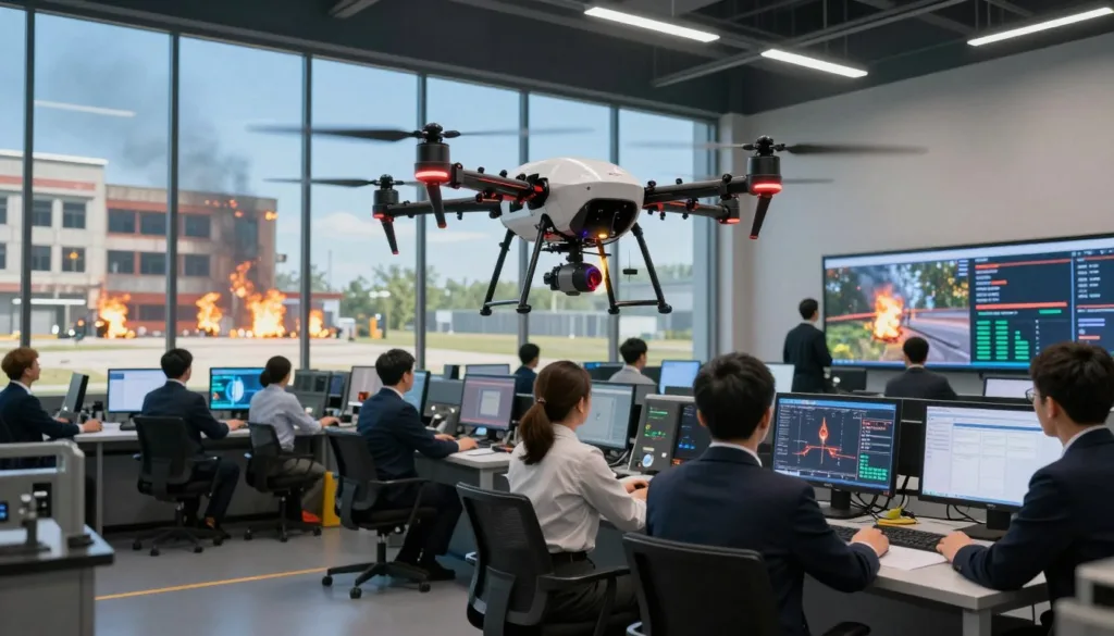
How to Operate a Firefighting Drone Simulator
Getting started with this innovative training tool involves two core areas: the interface and the procedures. Mastery here translates directly to confident and effective real-world performance.
Understanding the Simulator Interface
The main dashboard is your command center. It displays critical flight information, live video feeds, and system status indicators.
Multiple viewing windows show streams from various cameras. You’ll see thermal overlays, GPS data, and battery levels. This replicates the rich data environment of actual operations.
Modern platforms can simulate a launch in under 20 seconds. Live video feeds are often available within minutes. This teaches the vital skill of rapid situational assessment.
Key Operational Procedures
Key operations begin with pre-flight checks. You establish secure video links and calibrate sensors. Setting correct flight altitudes for aerial reconnaissance is crucial.
Trainees learn to conduct remote size-ups safely. They interpret streaming data to evaluate conditions and identify hazards. This allows for informed tactical decisions without physical risk.
Practice emphasizes integrating aerial intelligence with ground reports. Effective communication with incident commanders is a core lesson.
Understanding flight time limits is essential. Most missions offer a 26-45 minute window. Operators learn to plan efficient reconnaissance routes and prioritize critical areas.
Key Components of a Firefighting Drone Simulator
Cutting-edge training tools are built upon a foundation of precise data collection and seamless information flow. Their core parts work together to create a realistic and valuable practice environment.
Thermal Imaging and Sensor Capabilities
Specialized sensor arrays capture multiple types of information. Thermal imaging and infrared sensors detect temperature variations to find hidden hotspots.
High-resolution visual cameras, like 64MP sensors, provide crystal-clear details. Advanced equipment, such as the Teledyne FLIR Boson+, measures exact material temperatures.
Other sensors add crucial layers of intelligence. LiDAR systems map terrain with accuracy. Gas and smoke sensors analyze chemical composition during an event.
Communication and Data Integration Systems
All captured data streams securely to cloud nodes for immediate use. This real-time streaming teaches operators how to manage video and data transmission during critical moments.
This intelligence is relayed to ground units or command centers. It allows for informed decisions about fire behavior and fire spread.
The system replicates various drone models and their features. For example, one model offers a flight time of up to 41 minutes. Visual and thermal information seamlessly integrates into operations management software.
This integration supports comprehensive emergency response coordination for any team.
Setting Up Your Drone Simulator for Training
The initial setup phase transforms powerful software into a tailored learning environment. Proper configuration ensures your team experiences realistic and valuable practice sessions.
System Installation and Configuration
First, deploy the platform on your preferred infrastructure. You have three main choices for this system.
On-premises installation suits agencies needing strict data control. Edge deployment works for remote stations with spotty connections. Cloud-based solutions offer maximum accessibility.
The process configures virtual aerial fleets with advanced sensor packages. These replicate the multispectral data collection of real units.

Integrating Real-Time Data and Digital Models
Next, connect to live external streams. This integration pulls in weather models with wind patterns and humidity forecasts.
Geographical datasets add terrain maps and vegetation information. Historical incident repositories provide crucial context.
Digital twins form the virtual foundation. These detailed models recreate actual locations your department serves.
The environment refreshes continuously with new real-time data. Scenarios evolve, challenging teams to adapt strategies within minutes.
Configure safety features and operational boundaries during setup. Management controls let instructors adjust difficulty and monitor performance.
This prepares crews for coordinated operations during any emergency. The seamless flow of real-time data is key for effective training.
| Deployment Type | Best For | Key Advantage | Data Latency |
|---|---|---|---|
| On-Premises | Government agencies | Full data sovereignty | Low |
| Edge | Remote stations | Operates offline | Variable |
| Cloud-Based | Multi-team access | High scalability | Very Low |
Developing Emergency Response Skills Through Simulation
Emergency response teams can now hone their critical skills in a dynamic, virtual environment designed for high-stakes training. This method builds safer, more effective professionals by removing real-world risks.
Teams learn about combustion behavior and fire spread patterns. They coordinate multi-agency responses and optimize resource deployment strategies.
Building Situational Awareness
This training helps crews understand the complete picture of an emergency scenario. They use aerial reconnaissance data to assess fire spread and identify threatened areas.
Trainees learn to interpret thermal imaging data to detect hidden hotspots. They build mental models of how fire behavior changes across different terrains.
Practicing Tactical Decision-Making
Real-time dashboards display predicted spread maps and containment tips. Incident commanders learn to process multiple data streams quickly.
They must make informed choices under pressure within minutes. The system refines forecasts as conditions evolve, teaching dynamic adaptation.
This prepares teams for terrain-influenced blazes and coordinated response in challenging areas. Effective communication between ground crews and command is vital.
| Skill Developed | Training Focus | Real-World Impact |
|---|---|---|
| Situational Awareness | Interpreting aerial data and thermal feeds | Faster, more accurate initial size-up at an incident |
| Tactical Decision-Making | Using live dashboards for informed decisions | Improved resource deployment and crew safety |
| Multi-Agency Coordination | Practicing communication protocols | Smoother joint operations during large-scale emergency events |
| Adaptive Strategy | Responding to changing simulated conditions | Ability to pivot tactics as real fire conditions shift |
Implementing Best Practices for Drone Operations in Firefighting
A well-defined framework for unmanned aircraft use ensures safety and efficiency on every call. Clear protocols guide when and how to deploy these tools during an incident.
They provide a comprehensive picture of the situation quickly. This support extends from structure fires to disaster relief work.

Personnel safety is the top priority. Aerial units can approach hazardous areas without risk to crews. This gathers critical information while protecting teams.
Training should include all relevant staff, not just operators. Incident commanders and ground crews must understand the capabilities. This lets them make informed requests for aerial intelligence.
Standardized communication protocols are essential. They define how data flows from operators to command. Everyone gets the intelligence they need for tactical decisions.
Airspace coordination guidelines prevent interference with other aircraft. Regular practice maintains operator proficiency. These strategies maximize value while managing budgets wisely.
Creating reports with this technology is quick and cost-effective. It offers a superior approach to traditional fire protection resources. This makes advanced operations accessible for many departments.
Safety Protocols and Compliance in Simulation Training
The cornerstone of any effective training program lies in its commitment to safety and regulatory adherence. Modern platforms are built with safety-by-design principles at their core.
This protects both trainees and sensitive data during operations. It creates a secure space where fire departments can develop skills without physical risk.
Ensuring Operational Safety
Virtual environments let teams practice extreme emergency scenarios in complete security. Personnel can experience structure collapses or hazmat incidents safely.
This gives first responders valuable experience with high-risk situations. Autonomous systems teach how to minimize human presence in dangerous areas.
Proper resource deployment strategies are practiced. Teams learn to position aerial support while maintaining safe margins from active hazards.
Adhering to Regulatory Standards
Compliance with federal, state, and local rules is essential. Training incorporates requirements from agencies like the FAA.
In 2021, the FAA granted the first Beyond Visual Line of Sight waiver for this work. This was a major step for fire protection agencies.
The National Institute of Standards and Technology developed standardized tests in 2022. These provide reliable benchmarks for evaluating performance.
Training also emphasizes airspace coordination with manned aircraft. This prevents conflicts and maintains safe aerial environments during real emergency operations.
Enhancing Coordination Between Ground Crews and Aerial Units
The true power of modern emergency response emerges when teams on the ground and in the air work as one cohesive unit. This level of teamwork is perfected through specific protocols and seamless data sharing.
Training focuses on creating a unified operational picture. Everyone involved must understand and act upon the same critical information.
Facilitating Multi-Agency Communication
Clear communication channels are the first step. Different agencies learn to integrate their systems for smooth operations.
Personnel are taught to access shared real-time data streams. This includes live video feeds, interactive maps, and sensor information.
This integration ensures all responders coordinate their efforts from the same intelligence. Incident commanders can then make swift, informed decisions.
Leveraging Live Aerial Intelligence
Live aerial feeds provide unprecedented clarity during an emergency. They offer a top-down view that complements what crews see at the scene.
Thermal imaging is especially valuable. Advanced cameras can see through thick smoke to locate hidden hot spots.
This data supports better assessment and safer resource deployment. Continuous streaming allows teams to track how a situation evolves in real time.
Ground personnel learn to request specific aerial intelligence before entering dangerous areas. This balanced approach, using both ground and overhead perspectives, transforms emergency management for optimal outcomes.
Technology Advancements Shaping Firefighting Drone Simulators
Artificial intelligence is now at the forefront of creating smarter, more adaptive training environments for crisis teams. These intelligent solutions move far beyond basic flight practice.
Transitioning from Traditional Methods to AI-Driven Solutions
Advanced AI Decision Agents represent a major leap. They can orchestrate multi-unit swarms with remarkable precision. This teaches teams how to manage comprehensive aerial coverage for any emergency.
Edge computing is another key technology advancement. It enables ultra-low-latency updates in remote areas. Critical real-time data reaches command posts even with poor infrastructure.
These systems use collaborative learning to get smarter over time. They analyze fire behavior patterns and terrain from many regions. This builds accurate predictive models for diverse climate conditions.
New features include agent-to-agent communication. Multiple autonomous systems work together seamlessly. They can independently assess blaze characteristics and spread patterns.
This shift prepares human teams to work alongside intelligent support. The integration of AI doesn’t replace expertise—it powerfully augments it. Emergency management becomes more informed and effective.
Exploring Real-World Case Studies and Success Stories
Concrete evidence of success is best found in the documented experiences of frontline agencies. Leading fire departments across the nation demonstrate how this technology delivers during actual crises.
Lessons from the Los Angeles and New York Fire Departments
The Los Angeles Fire Department pioneered this use for emergency response in 2017. During the 2018 Woolsey fire, their units provided real-time aerial views.
This helped crews track progression and find hidden hotspots. The New York City Fire Department offers another strong example.
FDNY used this tool at a major Brooklyn warehouse incident. The live video feed gave commanders critical information.
This supported better decisions on resource deployment and safe routes. Both cases show how aerial reconnaissance gathers vital data from dangerous areas.
Innovative Applications and Future Trends
The Menlo Park Fire Protection District shows diverse operations. They used detailed imaging to plan a hazmat team’s approach to a chemical spill.
The Austin Fire Department also enhances its fire protection capabilities this way. These stories reveal common success factors.
Thermal imaging cameras detect heat in poor visibility. Teams leverage real-time information for tactical choices.
Future trends point to integrated systems with AI analytics. Training platforms will prepare crews to use these advanced models effectively.
| Department | Key Incident / Use Case | Primary Technology Applied | Outcome & Lesson Learned |
|---|---|---|---|
| Los Angeles (LAFD) | 2018 Woolsey Fire Monitoring | Thermal Imaging for Hotspot Detection | Enabled real-time tracking of fire spread and safer resource allocation. |
| New York City (FDNY) | Brooklyn Warehouse Fire | Live Video Feed for Situational Awareness | Provided commanders with aerial views for informed evacuation and deployment decisions. |
| Menlo Park Fire Protection District | Hazardous Material Spill Response | High-Resolution Aerial Imagery | Allowed safe remote assessment and detailed response planning without personnel exposure. |
| Austin Fire Department | Broad Operational Integration | Multi-Sensor Aerial Platforms | Demonstrates scalable adoption to enhance overall emergency response effectiveness and safety. |
Conclusion
Forward-thinking departments are embracing a new era of training that bridges virtual practice and real-world performance. These innovative solutions provide a truly transformative, risk-free environment for teams to prepare.
By combining cutting-edge aerial technology with sophisticated simulation, crews build critical skills in situational awareness and tactical coordination. This prepares first responders for complex emergencies with greater confidence.
Real-world success stories from leading agencies prove the value of this approach. As technology advances with AI and better integration, these tools will become even more essential for emergency response.
Whether starting out or enhancing your program, this guide aims to help you elevate your team’s capabilities. Embrace these powerful methods to achieve superior readiness and outcomes for your community.
FAQ
Why is the integration of unmanned aerial systems so important for modern fire departments?
These systems provide a critical aerial perspective that enhances safety and effectiveness. They deliver real-time data on fire spread and hotspot locations directly to incident commanders. This intelligence allows for smarter resource deployment and helps protect first responders by reducing their exposure to unnecessary risk.
What are the primary benefits of using a training platform for aerial units?
A high-quality training platform builds essential emergency response skills in a safe, controlled setting. Trainees can practice tactical decision-making using simulated thermal imaging and live video streaming data. This builds muscle memory for operational procedures and communication protocols before a real incident occurs.
How does thermal imaging technology work in these scenarios?
Specialized cameras detect infrared radiation, creating a visual map of heat signatures. This allows operators to see through smoke and identify hidden hotspots, fire behavior, and potential victims. This information is vital for creating accurate situation maps and guiding ground operations during complex incidents.
Can this technology help with coordination between different teams?
Absolutely. Effective multi-agency communication is a major focus. Live aerial intelligence from the unmanned system can be streamed to command centers and mobile devices in the field. This shared information ensures all teams, from ground crews to incident management, are making decisions based on the same real-time information.
What lessons have major departments like the Los Angeles Fire Department learned?
Pioneering departments have shown that early aerial reconnaissance is invaluable. Their success stories highlight how rapid deployment for size-up provides commanders with a complete operational picture within minutes. This has proven crucial for managing urban fires and wildland incidents, informing strategies for evacuation and fire attack.
What future trends are shaping this field?
The field is rapidly moving towards AI-driven solutions and better data integration. Future models will likely feature enhanced transmission systems, automated flight patterns for mapping, and predictive analytics for fire behavior. These advancements aim to provide even deeper insights and support for emergency response missions.

