
We deliver practical, industry-grade simulators that help teams master aerial skills with safety and speed. Our programs combine SRIZFLY platforms and real-world scenarios to build confidence before crews work on live assets.
Safety and efficiency guide every lesson. We focus on clear procedures, repeatable drills, and measurable outcomes so your staff can handle complex inspection tasks without risking equipment.
By using virtual scenarios, you gain the ability to rehearse fault finds and maintenance runs. This approach saves time, lowers costs, and raises the standard of operations at modern power facilities.
Key Takeaways
- Hands-on simulators: Practice complex maneuvers safely.
- SRIZFLY systems boost training efficiency and reduce field errors.
- Simulation rehearsals protect expensive gear and staff time.
- Structured courses improve inspection consistency across teams.
- We partner with you to deliver measurable, industry-ready results.
The Evolution of Solar Farm Maintenance
Modern solar farms rely on smarter workflows to manage millions of panels across vast terrain.
Noor Abu Dhabi illustrates the shift: the site spans 8 square kilometers and holds over 3.2 million panels. Since 2019 it has delivered clean energy to roughly 90,000 residents.
Traditional progress checks struggle at this scale. Multiple contractors, vast arrays, and complex wiring make manual methods slow and error-prone.
We advocate a tech-first approach. By integrating aerial systems and automated monitoring, teams spot degradation early and preserve overall efficiency.
- Scalability: Centralized data handles millions of panel records.
- Speed: Automated runs reduce survey time across farms.
- Reliability: Consistent checks protect renewable energy output for communities.
| Site | Area | Panels | Residents Served |
|---|---|---|---|
| Noor Abu Dhabi | 8 km² | 3,200,000 | ~90,000 |
| Typical Large Farm | 1–5 km² | 200,000–1,000,000 | Varies |
| Small Utility Site | <1 km² | <100,000 | Local grid |
Understanding Photovoltaic Power Plant Drone Inspection Simulation Training
We provide realistic virtual runs that teach crews to plan efficient flights and gather clean data. These exercises replicate site scale, module layouts, and common defect types so teams see real outcomes before going on site.
Defining Simulation Training
Simulated missions mimic field conditions without the risk of damaged gear. Operators practice routing, altitude control, and image capture in a controlled system. This reduces field time by about 70% and speeds up the learning curve.
Benefits of Virtual Environments
- Energy-aware flight planning: Learn path tactics that extend UAV battery life across large areas.
- Image and data processing: Identify module defects from high-resolution images before crews reach the ground.
- Streamlined maintenance process: Practice data workflows so field visits are focused and efficient.
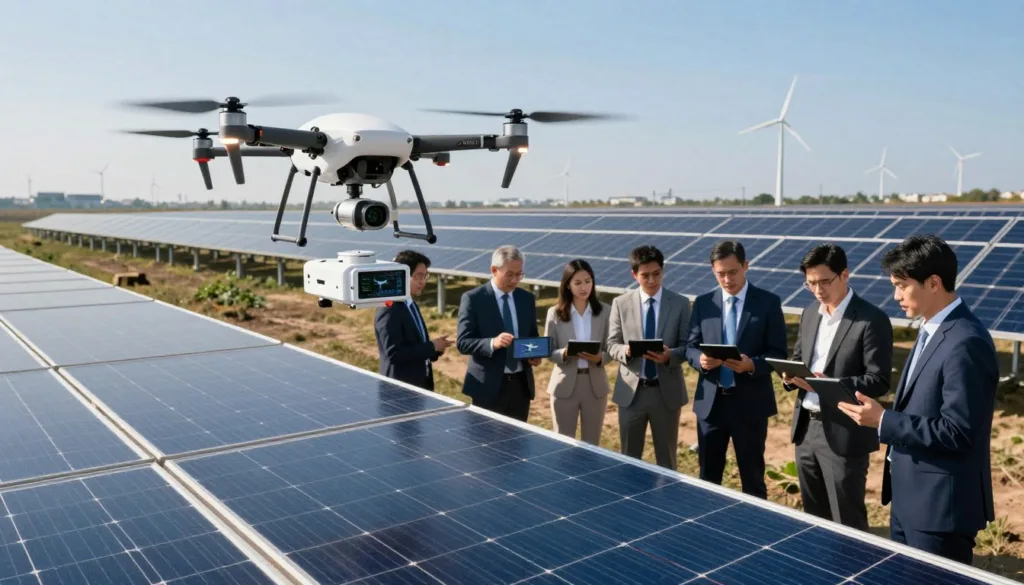
Key Advantages of Aerial Solar Inspections
Aerial surveys transform how teams detect faults across large solar fields. They extend reach across acres, reduce on-site time, and deliver consistent results that ground checks miss.
Safety improves immediately: UAVs keep crews off ladders and away from electrical hazards. That lowers incident risk and saves costly downtime.
Speed and efficiency follow. A single flight can capture high-resolution images of thousands of panels in a fraction of the time of manual walks. This shortens inspection cycles and accelerates defect detection.
Better data, better decisions: Integrated thermal and visual camera feeds let teams pinpoint hotspots and module faults that are invisible from the ground. Logged telemetry and image stacks create audit-ready records for maintenance planning.
- Cover vast farms faster—reduce field time by weeks.
- Capture detailed images for accurate defect detection.
- Lower personnel risk and boost operational efficiency.
We combine SRIZFLY systems with field-proven workflows so your team gets reliable results and faster return on maintenance time.
Overcoming Common Operational Pain Points
Scaling large solar arrays exposes staffing gaps that slow routine checks and delay fixes.
We tackle that gap with an automated approach that blends aerial data capture and fast detection workflows. This reduces backlog and helps your teams act faster.
Addressing Personnel Shortages
Automated UAV runs replace repetitive manual surveys. They collect consistent data across modules and panels, freeing technicians for targeted maintenance.
Advanced detection algorithms analyze images and flag defects. That shortens the processing time from collection to corrective work.
Our system scales with your site. You deploy fewer people to manage more arrays without sacrificing energy yield or safety.
| Challenge | Automation Benefit | Result |
|---|---|---|
| Labor gaps | Scheduled UAV data collection | Reduced field hours |
| Slow defect detection | AI-driven detection | Faster repairs |
| Data overload | Streamlined processing | Actionable reports |
We train your crew to run the system so you scale inspection capacity and protect site energy output. Your success drives our approach.
Essential Hardware for Modern Solar Inspections
Modern inspections demand hardware that combines range, ruggedness, and flexible sensor mounts. These traits let teams survey wide areas rapidly and collect reliable image data for fast detection of module defects.
Matrice Series Capabilities
The DJI Matrice 30 Series delivers an extended flight range up to 15 km and robust ingress protection for adverse weather. Its dual-control option enables safe handoffs during complex flights.
Payload Versatility
One-pass data capture speeds maintenance and reduces ground time. Equip the Matrice with high-resolution thermal camera sensors alongside RGB cameras to record temperature and visual image stacks in a single sortie.
Portable Solutions
Portability meets performance: Compact systems let teams move between farms quickly. We pair hardware with practical operating procedures so your crew performs rapid detection and effective module checks on the ground.
- 15 km range: Wide coverage per flight.
- RGB + thermal: Combined visual and temperature data.
- Weather-rated: Reliable operation in harsher conditions.
Integrating Thermal and Visual Imaging Sensors
Merging thermal scans with RGB imagery reveals faults that single sensors miss. This fusion helps teams make fast, accurate maintenance choices. We combine visual and thermal feeds so your crew sees both color detail and heat signatures in one workflow.
The Zenmuse H30T’s advanced thermal sensor (1280 × 1024) raises detection quality across large sites. Its resolution captures subtle temperature shifts that often signal early module failure.
We pair that thermal camera with high-resolution RGB cameras. The result: synchronized images and temperature overlays that speed anomaly identification. Operators learn to read both layers so every inspection flight yields actionable data.
- Comprehensive view: Visual thermal data captures hot spots and surface defects.
- Faster decisions: Combined image streams reduce false positives and cut follow-up time.
- Operator readiness: We train crews to interpret heat and color cues for reliable outcomes.
The Role of Automated Docking Stations
Remote docks handle recurring missions so teams can focus on analysis and repairs. Automated stations enable repeatable scheduling and reduce onsite setup time.
Automated Mission Scheduling
We deploy dock systems to run routine inspection flights without daily manual launches. The DJI Dock 3 supports an operating radius of 10 km and an IP56 rating for reliable outdoor use.
Using DJI FlightHub 2, you schedule missions and automatically collect image and thermal camera data. The system uploads findings to the cloud for fast processing and mapping.
“Automated docks turn repetitive sorties into consistent, audit-ready records.”
- Consistent inspections: Schedule recurring missions to capture comparable data across the solar farm.
- Streamlined mapping: Automatic uploads speed image processing and orthomosaic workflows.
- Integrated sensors: RGB and thermal camera payloads ensure every flight supports detection of energy issues.
We train your crew to manage the end-to-end process: mission setup, in-field monitoring, and cloud-based data review. This reduces ground intervention and lets your team focus on detection and fixes that preserve site energy output.
Optimizing Flight Paths for Energy Efficiency
Smart route planning stretches each battery charge so crews cover more modules per sortie.
We teach teams to map the most efficient routes across your solar farm. This reduces flight time and increases inspection coverage.
Our approach factors site layout, sun angle, and recharge points. That keeps the system running longer between returns to ground and cut recharges.
We pair RGB and thermal camera workflows so each pass captures the data needed for reliable defect detection. This avoids repeat flights and saves energy.
- Route sequencing: Minimize turns and altitude changes to conserve battery.
- Segment planning: Divide large areas into optimized legs for full module coverage.
- Resolution vs. range: Balance high-res images with longer flight range to inspect more panels per sortie.
| Goal | Technique | Result |
|---|---|---|
| Maximize coverage | Energy-aware path planning | More modules per flight |
| Reduce repeat runs | RGB + thermal capture in one pass | Lower mission time |
| Maintain data quality | Adjust altitude and overlap | Reliable defect detection |

Your team will learn an approach that saves time and energy while delivering audit-ready results. We focus on predictable routes so field crews act fast and with confidence.
Data Processing and Anomaly Detection Algorithms
Fast, reliable data pipelines turn raw images into clear maintenance actions within hours. We combine lightweight screening and deep classifiers so your crew moves from collection to repair with confidence.
Thermal Analysis Tools
Our thermal camera workflows flag temperature and heat anomalies across modules. MPP anomaly detection provides a quick, low-overhead screen before detailed image work.
AI-Driven Fault Classification
We use AI models—including YOLOv5—to classify defects on high-resolution uav images. These models separate clean and dirty panels and prioritize targets for field crews.
- Practical training: We teach operators to run processing pipelines and interpret visual thermal overlays.
- Efficient workflows: RGB and thermal fusion reduces repeat flights and speeds reporting.
- Accurate delivery: Processed data reaches your ground team fast for prompt detection and repair.
“Clear, actionable data is the difference between a scheduled check and a targeted fix.”
Simulation Training for Inspection Personnel
We deliver immersive scenarios that let inspection teams practice full missions in a safe virtual cockpit. Operators rehearse flight plans, camera settings, and emergency responses without risking costly hardware.
Visual and thermal imaging are core to our curriculum. Trainees switch between RGB and thermal camera feeds to spot defects and temperature shifts. This dual-sensor approach readies crews for real-world detection tasks.
Our system provides real-time feedback on flight paths and image quality. That helps technicians refine capture angles, overlap, and sensor calibration before field deployment.
Benefits for energy site operations: faster pre-deployment readiness, fewer field errors, and improved maintenance scheduling through reliable image data.
| Skill | Focus | Outcome |
|---|---|---|
| Flight handling | Route planning & emergency drills | Safer field sorties |
| Sensor workflows | RGB + thermal camera capture | Accurate detection of defects |
| Data capture | Image overlap & quality checks | Audit-ready reports for maintenance |
- Immersive runs: Master UAV controls and system procedures safely.
- Sensor integration: Learn to fuse images and temperature for reliable detection.
- Real-time coaching: Improve missions before you fly on site.
“Our simulators cut field learning time and raise data quality for rapid, confident decisions.”
Best Practices for Large Scale Solar Farm Surveys
Accurate mapping reduces rework and speeds maintenance across large sites. We teach methods that balance image quality, geolocation, and processing time. That approach keeps teams efficient and focused.
Orthomosaic Mapping Techniques
Use consistent overlap, calibrated camera settings, and verified ground control points. These steps yield orthomosaics with reliable coordinates and repeatable results.
Real-world data proves the approach. For Noor Abu Dhabi we created 17 orthomosaic maps with 5 cm accuracy. The team captured 105,000 high-resolution images to monitor progress and spot module defects.
- Manage data: Plan storage and processing to handle tens of thousands of images.
- Detect heat: Fuse thermal camera and RGB layers to find temperature anomalies quickly.
- Ensure coverage: Plan flights so every panel and module is mapped once with proper overlap.
| Metric | Value | Benefit |
|---|---|---|
| Orthomosaics | 17 maps | Site-wide progress tracking |
| Images | 105,000 | High-detail defect detection |
| Accuracy | ≤5 cm | Reliable maintenance coordinates |
“Accurate ground control is the single best investment for repeatable maps.”
Navigating Environmental and Weather Challenges
Weather and site conditions often dictate whether a mission returns usable images or wasted time.
We equip systems to handle dust, heat, and moisture. IP-rated platforms survive desert grit and high temps so your drone stays operational during long runs.
Shadowing and partial shading change how solar panels read in images. These effects hide defects or create false positives.
We teach planning and sensor selection to reduce that risk. Combining RGB and thermal camera feeds helps distinguish dirt, shading, and true thermal anomalies.
Our scenarios mimic gusts, glare, and dust storms so operators practice safe flight decisions. That real-time rehearsal improves detection and lowers reflight time.
- Weather-ready gear: Ingress protection for extended field life.
- Visual thermal fusion: Better detection of dirt and shading on solar panels.
- Processing workflows: Algorithms to normalize images captured in tough conditions.
| Condition | Risk | Mitigation |
|---|---|---|
| Dust / heat | Sensor fouling, downtime | IP-rated mounts; pre/post checks |
| Partial shading | False thermal spikes | RGB + thermal fusion; repeat passes |
| High glare | Poor image contrast | Adjust exposure; plan time-of-day |

Enhancing Safety Through Remote Operations
Remote operations let your team inspect assets from a safe control room, cutting exposure to on-site hazards. Operators can manage flights and review images without entering restricted areas. This reduces the risk of injury and keeps personnel clear of high-voltage zones and rooftop work.
Dual-control workflows add a vital safety layer. One pilot manages flight while a second operator monitors sensors and emergency actions. This shared responsibility boosts reliability during complex uav missions over large arrays.
We teach crews to run remote flight plans and to process detection data offsite. That shortens the time field crews spend near panels and lowers exposure to weather, electrical, and fall risks.
- Remote first: Conduct more work from the ground to reduce field hours and incidents.
- Dual control: Two-operator workflows improve safety and mission precision.
- Remote processing: Analyze images and detection results centrally to speed decisions.
“Moving operations offsite preserves safety while keeping detection and processing accurate and timely.”
Leveraging Cloud Platforms for Project Management
Uploading mission outputs to the cloud closes the loop between collection and corrective work. DJI FlightHub 2 and PIX4Dcloud give teams a single place to store, view, and act on inspection results.
We teach your team to use FlightHub 2 so images and telemetry upload securely and instantly. That improves collaboration and speeds decision making across field and office teams.
PIX4Dcloud’s timeline helps track repairs and measure panel efficiency over time. Teams see progress at a glance and prioritize tasks based on verified data.
Our courses show how to process maps and images in the cloud. You learn to run the full workflow: upload, process, review, and assign follow-up actions.
- Improve project efficiency: centralized files and role-based access.
- Real-time collaboration: share images and findings for faster fixes.
- Streamlined operations: track work orders against map timelines.
“Cloud-first project management turns scattered inputs into clear, actionable plans.”
Future Trends in Renewable Energy Asset Monitoring
Autonomous systems paired with AI will streamline monitoring for modern energy assets. We see more self-guided flights, smarter mapping, and faster image analysis driving higher efficiency across sites.
Edge analytics will process camera feeds near the sensor. That cuts upload time and flags anomalies in seconds. Teams spend less time sifting raw images and more time on repairs.
Pix4D and others already show use cases: turbine surveys and decommissioning scans for coal sites. These examples point to broader adoption across solar and wind plants.
Our services prepare crews to adopt these tools. We teach autonomous mission setup, AI review workflows, and best practices for image fusion.
“Autonomy and AI cut inspection loops and raise asset uptime.”
| Now | Near Future | Benefit |
|---|---|---|
| Manual sorties | Autonomous routines | Lower field hours |
| Batch uploads | Edge AI on camera | Faster fault detection |
| Separate maps & images | Live mapping fusion | Higher accuracy for power plants |
We lead the shift. Stay ahead and keep your assets competitive and sustainable. Ask about our SRIZFLY simulators and a 10-day free trial to test autonomous services on your sites.
Conclusion
, Adopting immersive simulators and smart processing turns raw imagery into timely operational insight.
We outlined how virtual rehearsals and system-led workflows improve efficiency and safety for modern solar sites. Mastering these systems shortens field time and produces cleaner, faster data for repairs and reporting.
Investing in professional training prepares teams to manage complex renewable energy assets with confidence. Leverage our SRIZFLY simulators to streamline data collection and maintenance routines.
Contact us today to learn how our solutions can boost site performance and protect long-term power output. Ask about a 10-day free trial to test results on your site.
FAQ
What is SRIZFLY simulation training for photovoltaic power plant drone inspection?
SRIZFLY offers immersive simulator software that replicates solar farm inspections with realistic flight physics, RGB and thermal camera feeds, and mission planning tools. We recreate module layouts, mapping routes, and typical defects so teams learn safe, efficient workflows before flying on site.
How does virtual training improve inspection efficiency and safety?
Virtual environments let technicians practice automated flight paths, visual and thermal imaging checks, and emergency procedures without risking hardware or downtime. Our data shows simulator-led programs reduce field training time and improve first-pass defect detection — boosting operational efficiency and safety.
Which sensors and cameras are covered by the simulator?
The platform supports a range of payloads — RGB, thermal, multispectral, and LiDAR — plus common inspection cameras from manufacturers like DJI and FLIR. This lets teams train on the same sensor suites they deploy in the field for accurate image capture and temperature mapping.
Can I simulate large-scale mapping and orthomosaic generation?
Yes. SRIZFLY simulates automated grid flights, overlap settings, and orthomosaic stitching workflows. Trainees can generate georeferenced maps and practice post-processing steps for defect localization and reporting across utility-scale arrays.
Does the simulator include AI-driven anomaly detection and thermal analysis tools?
The training suite integrates AI fault-classification models and thermal analysis modules so users learn how algorithms flag hotspots, string failures, and module defects. We also provide tools for reviewing algorithm outputs and refining inspection parameters.
How are flight paths optimized for energy and time efficiency?
The simulator models battery consumption, wind effects, and payload weight to train crews on optimal routing and mission scheduling. Users learn folding mission segments, waypoint planning, and automated return-to-dock to maximize coverage and minimize downtime.
What hardware platforms are modeled, including Matrice series capabilities?
We simulate common enterprise platforms such as DJI Matrice series, Autel, and similar UAVs — including payload integration, flight envelopes, and redundancy features. This helps pilots master specific airframes and plan for real-world constraints.
Can the simulator train teams on automated docking stations and mission scheduling?
Yes. Training modules cover automated docking interactions, charging cycles, and mission queuing so operators can practice continuous operations and reduce manual intervention in large farms.
How does the simulator help with personnel shortages and skill gaps?
Remote, repeatable scenarios let fewer instructors scale training across many operators. We provide assessment tools, scenario libraries, and measurable KPIs so organizations upskill staff faster and maintain inspection quality despite limited headcount.
Is weather and environmental variability part of the training?
The platform models weather effects — wind, glare, temperature variance, and seasonal light — so pilots learn when to delay flights, adjust sensor settings, or change routes to maintain data quality and safety.
How are visual and thermal data processed and stored for analysis?
Training covers end-to-end workflows: image capture, orthomosaic stitching, thermal correction, AI tagging, and secure cloud upload. We demonstrate integration with cloud platforms and asset-management systems for scalable project oversight.
Can we simulate portable solutions and field maintenance procedures?
The simulator includes portable inspection scenarios and ground-handling procedures — from payload swaps to quick repairs — so field crews learn rapid-response workflows and minimize site downtime.
What metrics and reports does the simulator generate for trainees?
SRIZFLY provides mission logs, flight-time analytics, detection accuracy reports, and training scorecards. These metrics help organizations track competency, refine SOPs, and demonstrate compliance with operational standards.
Does the training support orthomosaic mapping techniques for large arrays?
Yes. We teach planning parameters — GSD, overlap, flight altitude — and post-processing steps for high-accuracy orthomosaics used in asset management and long-term maintenance planning.
How does the simulator integrate with cloud platforms and project management tools?
The system supports secure exports and API links to common cloud services and asset-management platforms. This enables centralized data review, automated reporting, and collaborative fault remediation workflows.
Are there modules focused on AI-driven fault classification reliability?
We include modules that train users on model validation, false-positive handling, and retraining workflows. Trainees learn how to interpret model confidence, cross-check thermal and visual evidence, and feed corrections back into the pipeline.
What scale of operations can the simulator model — single-site to multi-farm?
The platform scales from small rooftop arrays to utility-scale farms, including multi-site scheduling and resource allocation. This helps planners optimize fleets, sensors, and maintenance cycles across portfolios.
How do we measure ROI from simulator-based inspection programs?
We recommend tracking reduced field hours, faster fault resolution, lower equipment risk, and improved detection rates. Case studies show simulator programs can cut on-site training time and increase inspection throughput substantially.
What is the best way to start — do you offer trials or onboarding support?
We offer a 10-day free trial and structured onboarding, including scenario setup, sensor calibration guides, and instructor training. Our team helps tailor content to your fleet and operational goals.

