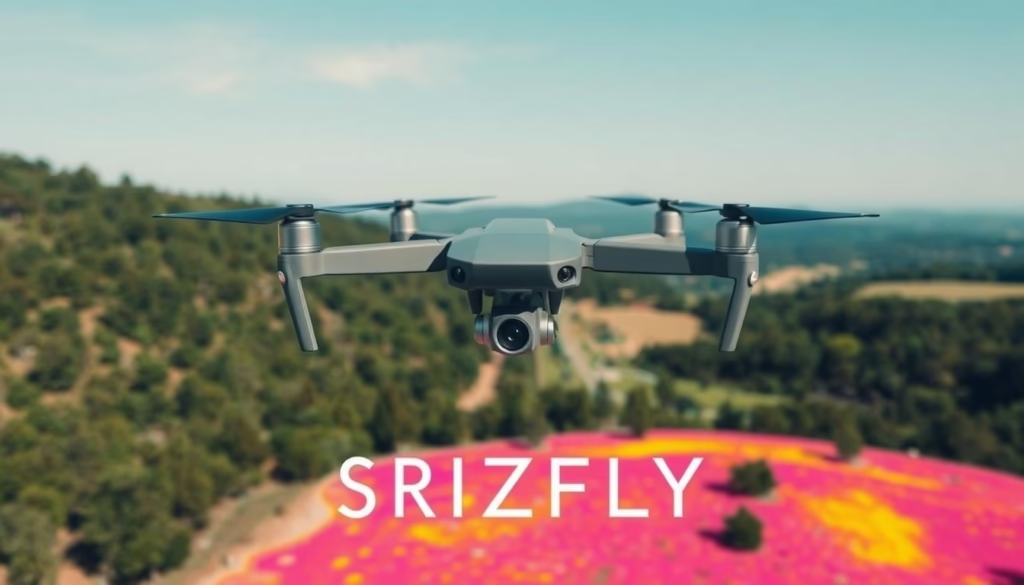
What if the key to enhancing your aerial imaging is not just improved camera resolution, but the transformative power of thermal imaging technology? The Mavic 3 Thermal, a sophisticated DJI drone, ushers in a new era of precision and capability, specifically designed for professionals in fields such as agriculture, emergency response, and infrastructure inspection. Utilizing the advanced SRIZFLY unmanned machine system, this drone combines dual-camera functionality and state-of-the-art features, ensuring reliability while capturing critical data in real-time.
Key Takeaways
- Featuring a 4/3 CMOS Wide Camera with a 20MP resolution.
- Maximum flight time of 45 minutes, covering up to 2 square kilometers.
- Resolution of the thermal camera reaches 640 × 512 pixels for precise imaging.
- 56× Hybrid Zoom capability offers detailed examinations from afar.
- Equipped with advanced features like APAS 5.0 for automatic rerouting.
- Real-time operation management supports annotations and mapping.
- Original price set at $5,498.00, ensuring high-quality performance validation.
Introduction to Mavic 3 Thermal Capabilities
The Mavic 3 Thermal stands out in the realm of drone technology, particularly due to its advanced thermal imaging capabilities. This feature captures infrared radiation emitted by various objects, enabling professionals to discern critical data not visible to the naked eye. Equipped with a high-resolution thermal imaging sensor of 640×512 pixels, the DJI thermal drone enhances mission effectiveness, serving diverse applications.
Understanding Thermal Imaging
Thermal imaging technology transcends conventional visual observation by detecting heat signatures. It plays a pivotal role in multiple fields, allowing operators to gather essential information during operations. The Mavic 3 Thermal leverages this technology to provide clear thermal visuals, contributing significantly to analytical assessments.
Applications of Thermal Imaging
The versatility of thermal imaging technology aids in numerous professional usage scenarios, including:
- Firefighting, where heat detection helps locate hot spots.
- Search and rescue missions, enabling quicker identification of individuals in distress.
- Infrastructure inspections, allowing for detailed thermal assessments of buildings and equipment.
- Agricultural monitoring, facilitating temperature evaluations of crops to optimize yield.
Benefits for Aerial Surveys
In the context of aerial surveys, using the Mavic 3 Thermal presents an array of benefits:
- Increased efficiency: The drone can cover vast areas swiftly, significantly reducing survey time.
- Temperature variation detection: Identifying anomalies in heat patterns enhances data accuracy.
- Improved decision-making: Real-time visuals and data allow for timely and informed operational choices.
| Feature | Description |
|---|---|
| Sensor Resolution | 640 x 512 pixels |
| Zoom Capability | 28× continuous zoom for enhanced situational awareness |
| Flight Time | Up to 45 minutes under optimal conditions |
| Obstacle Avoidance | Omnidirectional sensors for complete coverage |
| Data Security | AES-256 encryption for media storage |
Overview of the SRIZFLY Model
The SRIZFLY model serves as a prominent choice within the Mavic 3 series, designed specifically for professional applications. Its thermal imaging capabilities combined with impressive Mavic 3 specifications enhance functionality across various sectors.
Key Features of SRIZFLY
The SRIZFLY model boasts several key features, including:
- Thermal camera resolution of 640×512, allowing for detailed imaging.
- A 56x hybrid zoom camera, which facilitates greater visibility of distant objects.
- Advanced obstacle sensing technology to ensure safe operation.
- Flight time of up to 41 minutes, enabling extensive aerial surveys.
- Wind resistance capabilities up to 34 mph, making it a resilient option for challenging conditions.
Specifications of the Unmanned Machine
In terms of specifications, the SRIZFLY model showcases impressive features, such as:
| Specification | Details |
|---|---|
| Maximum Altitude | 7,000 meters |
| Maximum Range | 30 kilometers |
| Maximum Speed | Over 50 mph |
| Area Coverage | Up to 3 km² in a single flight |
| Battery Capacity | 5880 mAh |
| Operating Temperature Range | -20° to 50° C (-4° to 122° F) |
| Charging Time | Approx. 30 minutes to 90%, 50 minutes full charge |
Comparison with Other Mavic Models
A drone comparison indicates the SRIZFLY model surpasses other Mavic drones, particularly in imaging and operational efficiency. While the Mavic 3 features strong capabilities, including various intelligent flight modes, the SRIZFLY’s dual-camera system stands out. As professional demands evolve, the enhanced thermal imaging functions of the SRIZFLY model provide a significant advantage, catering specifically to specialized applications.

How Mavic 3 Thermal Enhances Security Operations
The Mavic 3 Thermal stands out as a superior asset for security operations. Its features enhance various applications, including monitoring, search and rescue, and infrastructure inspections. The integration of thermal imaging technology proves instrumental in effectively executing these critical tasks.
Monitoring and Surveillance
In the realm of drone security applications, the Mavic 3 Thermal shines with its advanced thermal imaging for surveillance. This technology allows for superior heat detection, enabling security personnel to monitor large areas, day and night. Its capability to operate in low visibility conditions can enhance operational effectiveness by up to 90%, allowing for timely identification of unauthorized activities. The rugged design and long flight time of up to 45 minutes facilitate extended surveillance missions, making it an ideal choice for law enforcement and public safety agencies.
Search and Rescue Missions
The application of the Mavic 3 Thermal in search and rescue missions illustrates its life-saving potential. Equipped with a thermal sensor that can detect body heat signatures, it significantly accelerates recovery efforts in challenging terrains. Studies show that using thermal drones can improve response times by 30% to 50%, with a reported 40% increase in successful missions compared to traditional strategies. This capability supports quick identification of individuals trapped in debris or stranded due to natural disasters, demonstrating the Mavic 3 thermal benefits in real-world scenarios.
Infrastructure Inspection
Utilizing drone security applications in infrastructure inspection is gaining momentum, and the Mavic 3 Thermal leads this shift. Its thermal imaging technology assists in identifying heat leaks, monitoring the structural integrity of critical systems, and detecting hazardous material leaks. With the ability to conduct evaluations from a safe distance, the Mavic 3 Thermal not only enhances operational efficiency but also contributes to safety compliance in various industries. The integration of real-time data visualization supports mission planning and execution, promoting effective decision-making during inspections.
Advantages of Choosing DJI
Selecting DJI products, particularly the Mavic 3 Thermal, presents numerous advantages that cater specifically to the needs of professional users. Known for quality and reliability, DJI has established a reputation for producing dependable drones that withstand rigorous operational demands. The Mavic 3 Thermal harnesses cutting-edge technology, ensuring optimal accuracy and performance across various applications.
Quality and Reliability
DJI advantages include built quality that guarantees longevity, making the Mavic 3 Thermal a trustworthy option for aerial surveys, inspections, and monitoring operations. The craftsmanship evident in the Mavic series translates to improved durability under challenging conditions, appealing to professionals seeking dependable drones.
Innovation and Technology
The integration of cutting-edge technology sets the Mavic 3 Thermal apart in the drone market. The advanced RTK positioning system provides centimeter-level accuracy, surpassing the capabilities of many competitors. With a flight time ranging from 36 to 45 minutes, users can accomplish extensive tasks in a single outing. The thermal sensor, featuring a resolution of 640 x 512 at 30 Hz, enhances operational efficiency through real-time temperature analysis, marking a significant advancement in the field.
User-Friendly Interface
The Mavic 3 Thermal demonstrates DJI’s commitment to user experience with its intuitive software interface. The DJI Pilot 2 application simplifies control, making it accessible for both novice and experienced pilots to operate the drone effectively. This user-friendly software streamlines the workflow, allowing operators to focus on capturing critical data without becoming overwhelmed by complex controls.

Integrating Mavic 3 Thermal into Your Workflow
Incorporating the Mavic 3 Thermal into professional workflows enhances operational efficiency across various industries. Utilizing advanced DJI software tools can significantly improve drone operation practices and enable seamless integration. This section discusses effective software tools, best practices, and notable case studies showcasing successful implementations.
Software and Tools for Enhanced Functionality
The integration of the Mavic 3 Thermal into daily operations is facilitated by several DJI software tools designed to optimize performance. Key tools include:
- DJI FlightHub 2: This mission management tool allows for live annotations and cloud mapping, enhancing drone fleet management.
- DJI Terra: This mapping software supports detailed analysis and planning for aerial surveys, improving data accuracy.
- DJI Pilot 2: It streamlines pre-flight setup, flight planning, and mission execution.
Best Practices for Use
Implementing best practices is crucial for effective workflow integration. Operators should consider the following:
- Plan missions meticulously by assessing environmental factors, ensuring optimal weather conditions.
- Utilize the Mavic 3 Thermal’s omnidirectional obstacle detection for safe navigation.
- Leverage the drone’s continuous zoom capabilities during operations to achieve detailed imagery.
Case Studies of Successful Implementations
Real-world applications demonstrate the impact of the Mavic 3 Thermal in various sectors. Here are a couple of examples illustrating its versatility:
| Industry | Application | Outcome |
|---|---|---|
| Agriculture | Crop Health Monitoring | Identified irrigation issues and enhanced crop yield. |
| Public Safety | Search and Rescue Operations | Successfully located missing persons using thermal imaging capabilities. |
Maintenance and Care for the Mavic 3 Thermal
Maintaining the Mavic 3 Thermal is essential for ensuring optimal performance and extending its operational life. Engaging in proper drone maintenance practices is imperative for professional users committed to aerial imaging. Utilizing the DJI care program offers structured support for routine checks and repairs.
Routine Maintenance Tips
Regular maintenance plays a critical role in avoiding potential issues. Essential recommendations include:
- Performing software updates to keep the drone’s firmware current.
- Conducting physical inspections to detect signs of wear and tear.
- Utilizing DJI Maintenance Services, which emphasize preventive care over reactive repairs.
Troubleshooting Common Issues
Understanding troubleshooting techniques is crucial for addressing basic operational problems. Some prevalent issues include:
- Battery performance inconsistencies, which may stem from improper care.
- Connectivity problems that can often be resolved through software updates.
- Camera malfunctions ensuring settings are correctly configured for optimal results.
Upgrading and Accessories
Enhancing the Mavic 3 Thermal’s capabilities can be achieved through various Mavic 3 accessories. Notable accessories include:
- Intelligent flight batteries to extend flying time.
- Protective cases to safeguard the drone during transportation.
- Additional payload options that expand the drone’s functionality for specific applications.
Future Trends in Aerial Thermal Imaging
The evolution of aerial thermal imaging is significantly influenced by thermal imaging technology developments that integrate artificial intelligence and machine learning, providing enhanced data processing capabilities. As these technologies advance, operators can expect greater accuracy and efficiency in tasks such as inspections and surveillance, equipping them with tools that allow for seamless processing and interpretation of thermal data.
Emerging Technologies
Emerging technologies are paving the way for new market potentials across various sectors, including agriculture, emergency services, and energy management. The integration of high-resolution sensors like the Mavic 3T’s 640 × 512 px thermal camera enables detailed assessments, even in challenging conditions such as smoke or fog. With advanced features like point and area temperature measurement, operators can gain insights into temperature variations, thereby improving operational performance in specific tasks.
Potential Market Applications
The impact on the drone industry is profound. Companies leveraging aerial thermal imaging can significantly enhance their operational capabilities. For instance, the Mavic 3E and Mavic 3T models, with their maximum flight times of 45 minutes and unparalleled obstacle sensing, are streamlining complex operations. As industries continue to adopt these technologies, the drone market will evolve, pushing the boundaries of potential applications further.
Impact on the Drone Industry
FAQ
What is the Mavic 3 Thermal drone and its primary purpose?
The Mavic 3 Thermal is a DJI drone designed specifically for enhanced thermal imaging capabilities, widely used in applications such as agricultural monitoring, infrastructure assessments, emergency responses, and security surveillance.
What are the key features of the SRIZFLY model?
The SRIZFLY model integrates a 640×512 resolution thermal camera, a 56x hybrid zoom camera, omnidirectional obstacle avoidance, and provides a flight time of up to 45 minutes, making it ideal for various professional tasks.
How does thermal imaging technology work?
Thermal imaging technology captures infrared radiation emitted by objects, which provides vital data that is not visible to the naked eye, enabling users to detect temperature variations and assess object conditions effectively.
What applications can benefit from using the Mavic 3 Thermal drone?
Key applications include firefighting, search and rescue operations, infrastructure inspections, agricultural monitoring, and security surveillance, all of which utilize the drone’s thermal imaging capabilities.
What advantages does DJI offer through the Mavic 3 Thermal?
DJI is known for its commitment to quality and reliability. The Mavic 3 Thermal offers robust technical features, including an advanced RTK positioning system, ensuring precision and efficiency in aerial imaging tasks.
What software tools are compatible with the Mavic 3 Thermal for operational enhancements?
Essential software tools like DJI FlightHub 2 for mission management and DJI Terra for mapping are compatible, enhancing the functional capabilities and integration of the Mavic 3 Thermal into professional workflows.
What are some maintenance tips for the Mavic 3 Thermal drone?
Routine maintenance tips include regular software updates, physical inspections for wear and tear, and utilizing proper battery management strategies to ensure optimal performance and longevity of the drone.
What are the emerging trends in aerial thermal imaging technology?
Future trends include advancements in AI and machine learning capabilities for enhanced data analysis, which are expanding potential market applications across industries like agriculture, emergency services, and energy management.
How does the Mavic 3 Thermal compare with other Mavic models?
The Mavic 3 Thermal distinguishes itself with its dual-camera systems and superior thermal imaging functions, offering enhanced capabilities specifically designed for specialized applications in comparison to other Mavic models.

